Mel Watkin
Home
ARTWORK
WORKS ON PAPER
Beauty is a Beast and Not a Weed series
BIRDLAND Series
TREES BARK
LARGE TREES
REVOLVING, 2013-2022
Chrysanthemum Morifolium & Family
MIGHTY CHRYSANTHEMUM TREE
FALLEN: MAST, 2009-2011
THE LACEMAKERS
MIMIC, 2010-2012
SMALL TREES
TREES: ROMA Series 2014-2017
SMALL TREES 2012
TREE: BLUE SILHOUETTE SERIES
TREE: WHY SERIES
TREE: TWO DANCERS SERIES
TREE: SPINNER SERIES
MORE SMALL TREES 2012
SMALL TREE 2010-11
SMALL TREE 2009
SMALL TREES 2008
SMALL TREES 2007
SMALL TREES 2006
MAPS
Mississippi River Charts
VISUAL BIOGRAPHIES
WATERWORKS
SPRAWL
*PERFECT WORLD*
COMPASS ROSE SERIES
ROADSIDE
WALL DRAWINGS & INSTALLATIONS
RIVER CAMPAIGN, 2013
RIVER ROOM, 2013
MORE WALL DRAWINGS & INSTALLATIONS
ARTISTS' BOOKS & MULTIPLES
Girls Can Do Anything: An artist's book
Notebook of Notes
Leaves of Revolving
Emergency Tree
Waterfall$ of NY--2009 100% Cotton S-Shirt
Pocket Road Atlas--2001 Cover & 8 full color pages
Ipmoea Purpurea--1998
Black & Blue: Hearts and Minds: An Artist's Book, 1991
CATALOGS & PUBLICATIONS
News
Short Bio
CV
Contact
Links
Catalogs
MAPS
>
WATERWORKS
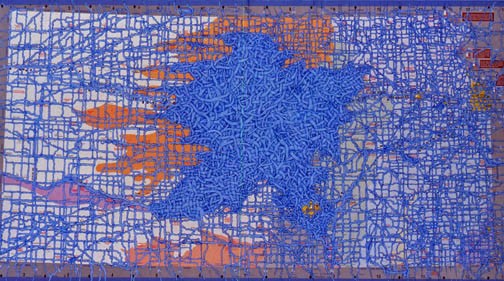
Kansas
Pen and acrylic on a road map of Kansas
19 ¾ x 36 inches
2005
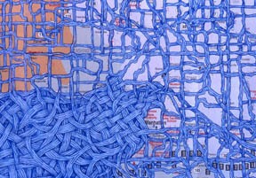
Kansas–DETAIL
Ink and acrylic on a road map of Kansas
19 ¾ x 34 ¾
2005
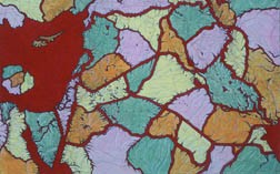
Red Seas
Ink and acrylic on a map of the Mideast
20 1/8 x 31 inches
2006
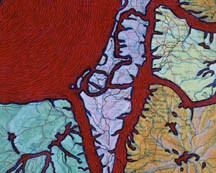
Red Seas –– DETAIL
Ink and acrylic on a map of the Mideast
20 1/8 x 31 inches
2006
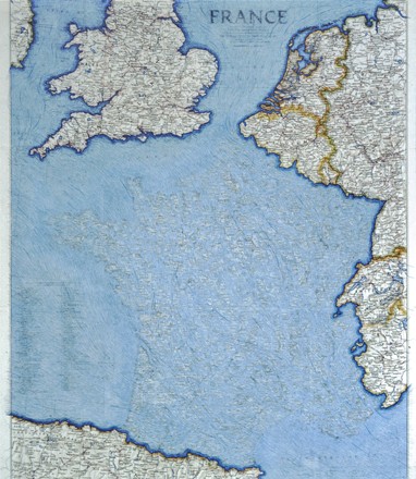
France
Pen, acrylic on a tourist map of France
25 ¼ x 20 ½ inches
2005
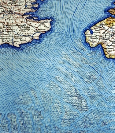
France –– DETAIL
Pen and acrylic on a map of France
25 ¼ x 20 ½ inches
2006
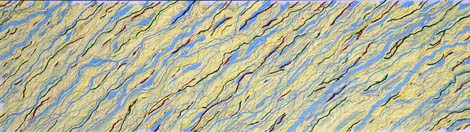
Autumn Rhythm
Pen and acrylic on a road map of Tennessee
19 ¾ x 34 ¾ inches
2006
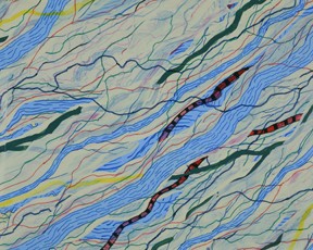
Autumn Rhythm –– DETAIL
Ink and acrylic on maps of Tennessee
19 ¾ x 34 ¾ inches
2006